
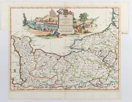
395
Carta Geografica del Governo Della Normandia, Venice 1740
Engraving, 375 x 482 mm. Map of Normandy based on De L'Ise's map.
Fresh impression on thin laid paper with watermark. Hand colouring. Usual editorial fold. In very good condition except for the cut-outs on the right and left margins.
Time auction 349
PRINTS, DRAWINGS AND MAPS
fri 13 June - tue 15 July 2025