

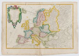
409
L'Europe divisée en ses principaux Etats, 1782
Acquaforte e bulino, 360 x 508 mm.
Mappa d'Europa stampata su carta vergata senza filigrana, con margini preservati e una bella coloritura a mano. In buono stato di conservazione: presenta alcune leggere gore, soprattutto sui margini, lievi bruniture e sgualciture lungo la piega centrale. Strappi sul bordo inferiore fermati al verso con nastro.
€ 200,00 / 300,00
Estimate
€ 100,00
Starting price
Unsold
Time auction 349
PRINTS, DRAWINGS AND MAPS
fri 13 June - tue 15 July 2025