

247
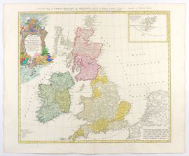
Regnorum Magnae Britanniae et Hiberniae Mappa Geographica..., 1749
Etching, 537 x 644 mm.
Map of Great Britain with part of the Netherlands print on laid paper. Usual editorial fold. Hand colouring. Overall in very good condition.
Live auction 294
Drawings, Prints and Geographical Maps from the 16th to the 19th Century
Palazzo Caetani Lovatelli, fri 19 April 2024
SINGLE SESSION 19/04/2024 Hours 15:00