
520
Mount & Page (Richard Mount (1654–1722) & Thomas Page (active 1700-1733))
A New Chart of the Coast of the Mediterranean sea from Cádiz and Cape Spartel to Cape Pallos and Cape Fallcon
Nautical chart of the Mediterranean Sea between the Spanish coast and the African coast, from Cadiz and Cape [..]
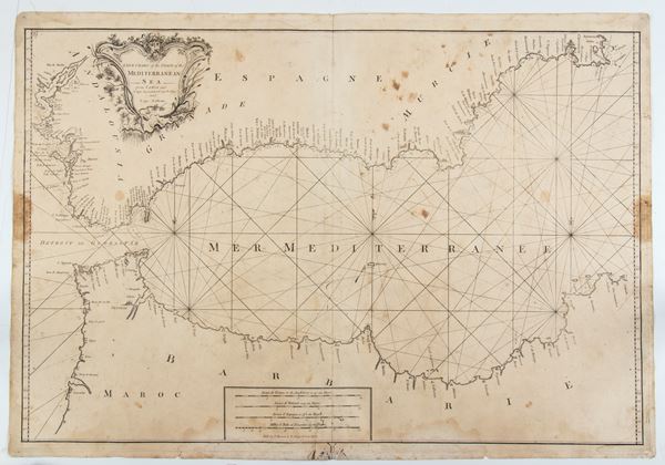
520
Mount & Page (Richard Mount (1654–1722) & Thomas Page (active 1700-1733))
A New Chart of the Coast of the Mediterranean sea from Cádiz and Cape Spartel to Cape Pallos and Cape [..]
Nautical chart of the Mediterranean Sea between the Spanish coast and the African coast, from Cadiz and Cape [..]
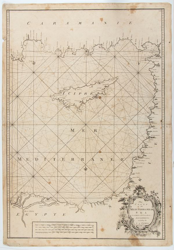
521
Mount & Page (Richard Mount (1654–1722) & Thomas Page (active 1700-1733))
The Coast of the Mediterranea Sea from Rusato and Gironda to Alexandreta including the I. of Cyprus
Nautical chart of the Mediterranean Sea with the Turkish, Israeli, Syrian and Egyptian coasts, and the island [..]
521
Mount & Page (Richard Mount (1654–1722) & Thomas Page (active 1700-1733))
The Coast of the Mediterranea Sea from Rusato and Gironda to Alexandreta including the I. of Cyprus
Nautical chart of the Mediterranean Sea with the Turkish, Israeli, Syrian and Egyptian coasts, and the island [..]
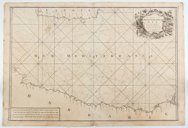
522
Mount & Page (Richard Mount (1654–1722) & Thomas Page (active 1700-1733))
The Coast of the Mediterranean Sea from Cape Razatin to Alexandria, with part of the Island of Candia
Nautical chart of the Mediterranean Sea between the African coast and the island of Crete. Etching and engraving, [..]
522
Mount & Page (Richard Mount (1654–1722) & Thomas Page (active 1700-1733))
The Coast of the Mediterranean Sea from Cape Razatin to Alexandria, with part of the Island of Candia [..]
Nautical chart of the Mediterranean Sea between the African coast and the island of Crete. Etching and engraving, [..]
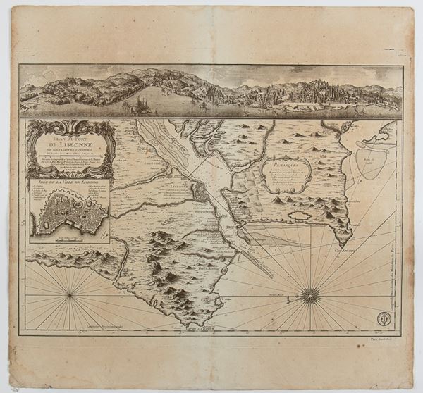
523
Jacques-Nicolas Bellin
(1703 - 1772)
Plan du Port de Lisbonne et des Costes voisines
Paris 1756
Map of the port of Lisbon and the surrounding coast, with a view of the city on the Tagus River in the upper [..]
523
Jacques-Nicolas Bellin
(1703 - 1772)
Plan du Port de Lisbonne et des Costes voisines
Paris 1756
Map of the port of Lisbon and the surrounding coast, with a view of the city on the Tagus River in the upper [..]
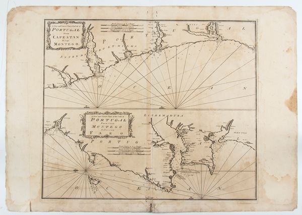
524
Mount & Page (Richard Mount (1654–1722) & Thomas Page (active 1700-1733))
A new and correct chart of the coast of Portugal from Cape Stan to Cape Montego | A new and correct chart of the coast of Portugal from Cape Montego to Pont de Faro
Map of the Portuguese coast from "A complete set of new charts on thirty-eight large plates containing an accurate [..]
524
Mount & Page (Richard Mount (1654–1722) & Thomas Page (active 1700-1733))
A new and correct chart of the coast of Portugal from Cape Stan to Cape Montego | A new and correct [..]
Map of the Portuguese coast from "A complete set of new charts on thirty-eight large plates containing an accurate [..]
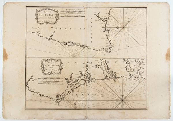
525
Mount & Page (Richard Mount (1654–1722) & Thomas Page (active 1700-1733))
The Coast of Portugal from River de Sinistra to Siluis | The Coast of Andalouisie from Siluis to Pallos
Map of the Portuguese coast taken from "A complete set of new charts on thirty-eight large plates containing [..]
525
Mount & Page (Richard Mount (1654–1722) & Thomas Page (active 1700-1733))
The Coast of Portugal from River de Sinistra to Siluis | The Coast of Andalouisie from Siluis to Pall [..]
Map of the Portuguese coast taken from "A complete set of new charts on thirty-eight large plates containing [..]
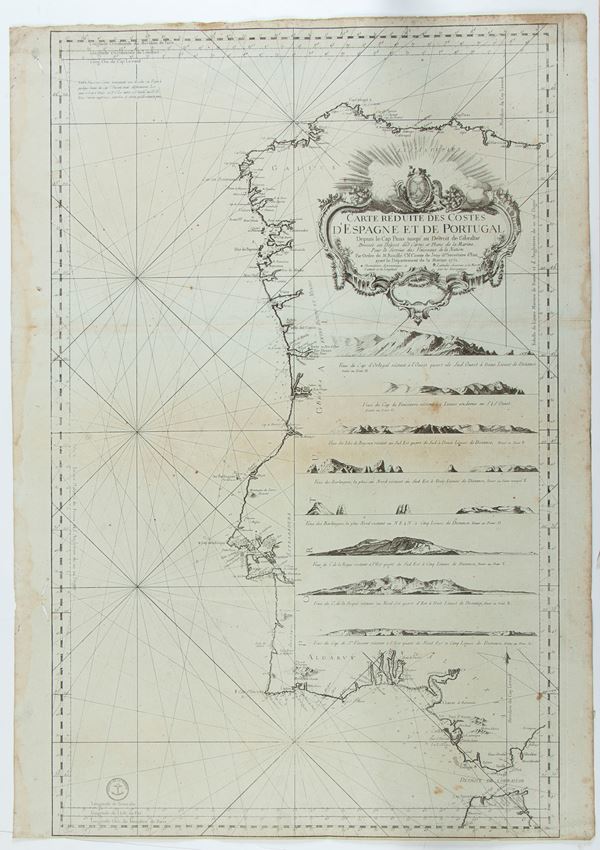
526
Jacques-Nicolas Bellin
(1703 - 1772)
Carte Reduite Des Costes D'Espagne et de Portugal
1751
Nautical chart of the coasts of Spain and Portugal. Etching and engraving, 890 x 630 mm. Printed on heavy laid [..]
526
Jacques-Nicolas Bellin
(1703 - 1772)
Carte Reduite Des Costes D'Espagne et de Portugal
1751
Nautical chart of the coasts of Spain and Portugal. Etching and engraving, 890 x 630 mm. Printed on heavy laid [..]
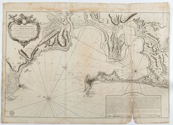
527
Jacques-Nicolas Bellin
(1703 - 1772)
Carte Hydrographique de la Baye de Cadix
London 17772
Hydrographic map of the Bay of Cadiz (Spain). Engraving and etching, 630 x 880 mm. Fine impression printed [..]
527
Jacques-Nicolas Bellin
(1703 - 1772)
Carte Hydrographique de la Baye de Cadix
London 17772
Hydrographic map of the Bay of Cadiz (Spain). Engraving and etching, 630 x 880 mm. Fine impression printed [..]
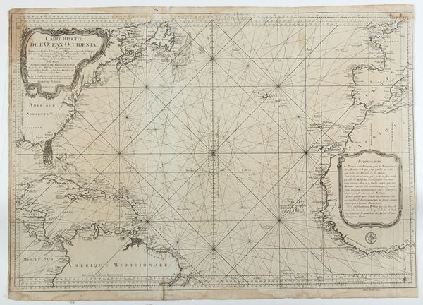
528
Jacques-Nicolas Bellin
(1703 - 1772)
Carte Reduite de L'Ocean-Occidental Comprenant les Cotes d'Europe et d'Afrique, depuis le 51 degre de Latitude Nord Jusqu'a l'Equateur et les Cotes
1766
Nautical map of the Atlantic Ocean, north of the equator, with the coast of North America, Florida and the coasts [..]
528
Jacques-Nicolas Bellin
(1703 - 1772)
Carte Reduite de L'Ocean-Occidental Comprenant les Cotes d'Europe et d'Afrique, depuis le 51 degre de [..]
1766
Nautical map of the Atlantic Ocean, north of the equator, with the coast of North America, Florida and the coasts [..]
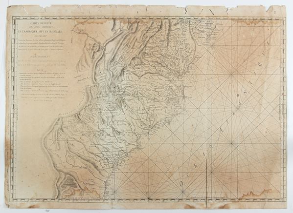
529
Antoine de Sartine
(1729 - 1801)
Carte Reduite des Cotes Orientales De L'Amerique Septentrionale Contentant Partie du Nouveau Jersey, la Pen-sylvanie, le Mary-land, la Virginie, la Caroline Septentrionale, la Caroline Meridionale et la Georgie...
Rome 1799
Italian edition of Sartine's map of the Atlantic coast, from the Chesapeake Bay and Delaware Bay to the mouth [..]
529
Antoine de Sartine
(1729 - 1801)
Carte Reduite des Cotes Orientales De L'Amerique Septentrionale Contentant Partie du Nouveau Jersey, [..]
Rome 1799
Italian edition of Sartine's map of the Atlantic coast, from the Chesapeake Bay and Delaware Bay to the mouth [..]
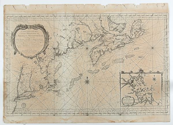
530
Jacques-Nicolas Bellin
(1703 - 1772)
Carte Reduite Des Costes Orientales De L'Amerique Septentrionale...contenant L'Isle Royale...La Nouvelle Angleterre et la Nouvelle Yorc
Paris 1757
Map of the East Coast of the United States, with New York, Connecticut, Rhode Island, Massachusetts, New Hampshire, [..]
530
Jacques-Nicolas Bellin
(1703 - 1772)
Carte Reduite Des Costes Orientales De L'Amerique Septentrionale...contenant L'Isle Royale...La Nouvelle [..]
Paris 1757
Map of the East Coast of the United States, with New York, Connecticut, Rhode Island, Massachusetts, New Hampshire, [..]
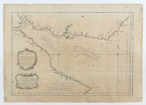
531
Jacques-Nicolas Bellin
(1703 - 1772)
Mapa y Planta del Rio de la Plata Leventada y Emendada novamente por los Pilotos del Rey . . . Carte Hydrographique de la Riviere de la Plata
Paris 1770
Map depicting the mouth of the Rio de la Plata between Argentina and Uruguay. Etching and engraving, 445 x [..]
531
Jacques-Nicolas Bellin
(1703 - 1772)
Mapa y Planta del Rio de la Plata Leventada y Emendada novamente por los Pilotos del Rey . . . Carte [..]
Paris 1770
Map depicting the mouth of the Rio de la Plata between Argentina and Uruguay. Etching and engraving, 445 x [..]
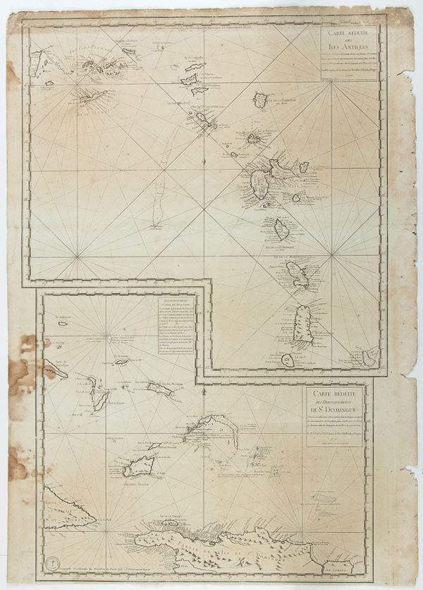
532
Carte Reduite des Isles Antilles | Carte Reduite des Debouquements de St Domingue
Paris 1775
Double map: the first of the Windward Islands from Puerto Rico to Barbados, the second showing the Turks and [..]
532
Carte Reduite des Isles Antilles | Carte Reduite des Debouquements de St Domingue
Paris 1775
Double map: the first of the Windward Islands from Puerto Rico to Barbados, the second showing the Turks and [..]
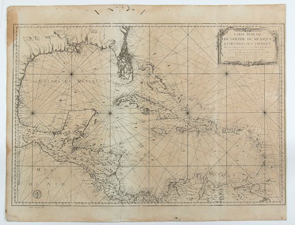
533
Jacques-Nicolas Bellin
(1703 - 1772)
Carte réduite du golphe du Mexique et des isles de l'Amérique
1774
Nautical chart of the Gulf Coast, showing the Gulf of Mexico, Guatemala, Nicaragua, Costa Rica and Panama. [..]
533
Jacques-Nicolas Bellin
(1703 - 1772)
Carte réduite du golphe du Mexique et des isles de l'Amérique
1774
Nautical chart of the Gulf Coast, showing the Gulf of Mexico, Guatemala, Nicaragua, Costa Rica and Panama. [..]